
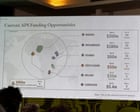
The United States government has found itself in an embarrassing global spotlight after a map of the African continent, displayed during a high-profile presentation in Brazil, astonishingly mislabeled every single country. The gaffe occurred at the AIDS 2026 conference in Rio de Janeiro this week, a major international gathering of health experts and policymakers.
The deeply flawed infographic was showcased midway through a US State Department presentation on new health agreements, leaving attendees stunned. Screenshots of the erroneous map quickly circulated across social media platforms, turning an official government address into a viral moment of ridicule.
Diplomatic Faux Pas Ignites Online
Reuters World reported experiencing a video of the presentation, vividly capturing the moment the map was displayed. The sheer scale of the error – not a single African nation correctly identified – immediately drew gasps and murmurs from the audience. Far from being a minor oversight, the map depicted a jumble of incorrect names, with countries like 'Sudan' appearing where 'Egypt' should have been, and 'Nigeria' adorning the territory of 'South Africa', for example.
The quick dissemination of images online turned the gaffe into a public relations nightmare for the State Department. Tweets and posts from irate attendees and global citizens alike expressed a mixture of disbelief, frustration, and accusations of ignorance. One Twitter user, whose post quickly garnered thousands of likes, quipped, "Did they just pull this map out of a cracker jack box? This is genuinely insulting." Another, a delegate from a West African nation, reportedly expressed their anger, stating such an error 'undermines the very spirit of collaboration and respect' at such a crucial conference.
State Department Concedes "Full Responsibility"
In the wake of the growing international backlash, a spokesperson for the US State Department was quick to issue a statement, acknowledging the severe error. "The US State Department takes full responsibility for the erroneous, widely shared chart displayed at the AIDS 2026 conference in Brazil," the statement read. While expressing regret, the spokesperson did not elaborate on the specific cause of the monumental cartographic failure or how such a deeply flawed graphic made it into an official presentation at a global summit of this magnitude.
The incident has raised serious questions about internal vetting processes and geographical literacy within certain branches of the US government. For an agency dedicated to international relations and diplomacy, an error of this nature is particularly galling, especially when dealing with a continent as diverse and geopolitically significant as Africa.
Broader Implications for Global Health Initiatives
Beyond the immediate embarrassment, the gaffe has, for some, cast a shadow over the seriousness of the US commitment to global health initiatives, particularly in Africa. While the State Department was presenting crucial agreements aimed at improving health outcomes, the visual blunder inadvertently communicated a lack of attention to detail and, more broadly, a perceived disrespect for the very nations the agreements are intended to benefit.
Australia's own Department of Foreign Affairs and Trade (DFAT) has invested hundreds of millions of Australian dollars in health and development programs across Africa, understanding the critical importance of accurate geographical and cultural understanding. Observers note that such an error originating from a major global power could, even if momentarily, detract from the substance of vital discussions on AIDS prevention and treatment, areas where international cooperation and trust are paramount. The State Department's swift apology aims to mitigate the damage, but the lingering image of the mislabeled map serves as a stark reminder of the importance of geographical accuracy in global diplomacy.